Hastings County - iCycle.Bike

iCycle.Bike

πŸ‡ΊπŸ‡Έ$ USD
  • πŸ‡¨πŸ‡¦$ CAD
  • πŸ‡ͺπŸ‡Ίβ‚¬ EUR
  • πŸ‡¬πŸ‡§Β£ GBP
  • πŸ‡¦πŸ‡Ί$ AUD
  • πŸ‡³πŸ‡Ώ$ NZD

Hastings County

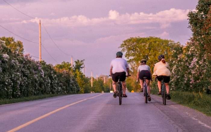
Cycling from Stirling to Marmora. Credit: Laura Voskamp

With its rolling farmlands, verdant forests, and inviting downtowns, Hastings County offers rural haven offers an authentic escape from the hustle and bustle of city life, a 90min drive/160km east of Toronto, and 2 hours drive/200km west of Ottawa. Stretching from the southern border of Algonquin Park (Maynooth, Bancroft) to the northern shore of Lake Ontario (Belleville), Hastings County offers a wide variety of road cycling experiences and a number of excellent regional and cross-regional trail systems and routes, including:

  • Explore a curated collection of gravel and backroad cycling routes, all with GPS maps for navigation.
  • Explore rugged rail trails, making up portions of the Trans Canada Trail, including the Hastings Heritage Trail and the Kaladar Trail
  • Explore old settlement roads, rugged trails and backroads on a multi-day bikepacking adventure, like the COLT Loop.
  • Additionally, Hastings County offers a number of trail networks suitable for mountain biking across the region.

Hastings County – Gravel Riding Routes

25 primarily on-road gravel cycling routes, ranging from 15km to 270km, exploring all 14 municipalities across the county, each with their own unique attractions & character. Ride through peaceful forests, charming communities, and wide open farmlands. From the rugged beauty of Bancroft to the peaceful tranquility of Limerick, there’s no shortage of things to do and see here. Suitable for beginners and pros. Keep your eyes peeled for the elusive wildlife!

All routes are mapped on the Ride with GPS website and app, offering free offline maps and downloadable PDF maps and cue sheets.Β  For more info, visit www.hastingscounty.com/adventures/cycling.

Discover curated Collections that fit the specific cycling adventure you have in mind:
  • Day Rides – Collection of local loops that pass through some of our communities, with stops at nearby restaurants and other attractions.
  • Beach Bound – These routes pass right through some of Hastings County’s best swimming holes and lakeside beaches.
  • Lilac Viewing Rides – A showcase of routes that contain some classic Hastings County roads framed with lilacs in May and early June.
  • Conservation Areas – Roll through some of Hastings County’s pristine conservation areas on any of these routes.
  • Overnighters and Bikepacking Routes – Load up your camping gear and immerse yourself in Hastings County’s rural and remote routes.
  • Fall Colours Rides – Fall brings some of the best riding in Hastings County, so we’ve collected some of our top routes for leaf peeping.

South Eastern Ontario Cycling Itineraries – Find 11 cycling itineraries and routes, (a mix of roads and trails), for the south eastern region of Ontario (Quinte/Prince Edward County to Cornwall), available online and as a downloadable print resource in English and French. Additional route suggestions included. These itineraries provide cyclists of all abilities with detailed information on routing, communities and amenities along the way, updated in 2023. Visit: www.southeasternontario.ca/cycling

  • Bay of Quite (West) – One of the 11 featured itineraries, this 68km loop will take cyclists on a ride exploring the cities of Belleville and Quinte West, arching north from the Bay of Quinte and through Hastings County.

Bancroft & North Hastings – Two Day Itinerary – These two routes are favoured by local cyclists for advanced training and are based on routes set for the legendary annual Hastings Highlands Hilly Hundred event and challenge. Using Bancroft as a convenient centre, stock up on all you need before heading out. The roads are quiet, services limited to nil and are perfect for club groups with motel accommodations in Bancroft, or smaller road crews wanting unique accommodations or camping closer to Algonquin Park.

For more regional maps, cycling info and Ontario By Bike listings for the southern portion of Hastings County, visit the South Eastern Ontario – Great Places to Cycle page.

  • Hasting County Trail – Part of the Trans Canada Trail, this course gravel surface trail is approximately 66 km heading east from the border of Northumberland County to Lennox & Addington County, north east to Tweed. For more info, use the Trans Canada Trail website’s β€œExplore The Trail” feature to find access points.
  • Kaladar Trail – Part of the Trans Canada Trail, this 17 km multi-use, unpaved trail links west to the Hastings County Trail at Tweed and east to Sharbot Lake via Central Frontenac Trailway. For more info, use the Trans Canada Trail website’s β€œExplore The Trail” feature to find access points.
  • Lower Trent Rail Trail – 17km rail trail running north from Trenton/Quinte West through Battawa to Glenn Ross. Enjoy a variety of scenery through quiet fields and woods. The trail is free of motorized vehicles (e-bikes allowed) in the summer has a smooth crushed gravel surface. From the southern end of the trail there is a short detour to the Bleasdell Boulder Conservation Area where you can view a massive boulder left from the ice age.
  • Two Lakes Rail Trail – 38km rail trail running north from Belleville to Madoc, intersecting with the Kaladar Rail Trail at Ivanhoe Station. The surface is course and heavily used by ATVs and snowmobiles, suitable to more experienced riders on mountain bikers. The trail is characterized by The trail has gentle curves, forests and marshes.
  • Centre Hastings Heritage Loop – A looped network of motorized multi-use trails spans 156 km from Glen Ross in Quinte West to its most northerly point adjacent to Lake St. Peter Provincial Park in Hastings. Visit website for more information and interactive map.
  • Silent Lake Provincial Park (Brancroft)- The park offers two loops; 11 and 17 km in length. The 11 km loop is moderately difficult, while the 17 km loop is considered difficult. Caution should be taken as the trail crosses the park road and is shared track in some portions. The trails are subject to closure during spring/wet conditions.Β  Please contact park for up to date information. The trail can be accessed from the day use area parking area.
  • Kamaniskeg Lake Β (Hastings Highlands) – 19km of doubletrack former logging roads. Kamaniskeg Lake and area, north of the Madawaska River from Bark Lake Dam to Combermere. Largest town in the region is Barry’s Bay at the north end of the lake. Most the the trails shown on the Trailforks map are former logging roads that are now primarily doubletrack ATV trails in summer and snowmobile trails in winter.
  • Vanderwater Conservation Area (Tweed) –  16km trail network through mature forests and to the Moira River where the water cascades over a series of limestone steps. Passive Biking only is allowed – the activity in which individuals on bicycles traverse designated trails outlined by the Authority at a leisurely pace that would not pose a danger to trail users or wildlife, and would have minimal environmental impact.

Trans Canada Trail (TCT) – Over 150 km of this cross-Canada route runs through Hastings, Frontenac and Lennox & Addington counties, with an additional 16 km proposed as part of the Frontenac K&P Trail. The TCT is a four-season, multi-use trail system with various surface types and users. This signed route is primarily off-road and on gravel trails in the region and presents multiple route options for day or multi-day cycling trips. Use the website’s β€œExplore The Trail” feature to find access points.

The Central Ontario Loop Trail (COLT) – This 450km loop is a popular multi-day bike packing route that incorporates the Victoria Rail Trail, The Ganaraska Trail, The Hastings Heritage Trail, The IB & O Rail Trail, and cuts through the Ganaraska Forest. Trail surfaces vary, a mountain or cross bike is recommended. With a variety of scenic landscapes the route passes through a number of smaller communities with services and accommodation or camping options. Link provided is directed to blog article, currently best source for information.

Great Lakes Waterfront Trail – Stretching over 3600km, the Great Lakes Waterfront Trail is a route connecting over 151 communities and First Nations along the Canadian shores of the Great Lakes: Lake Ontario, the St. Lawrence River, Lake Erie, Detroit River and Lake St Clair, Lake Huron, Georgian Bay and the North Channel. The fully signed Trail uses the safest infrastructure possible, a mix of both on-road and off-road facilities, and is primarily paved, with sections of unpaved path and gravel roads. It can be enjoyed for as part of a day trip or on a multi-day long distance cycling adventure.

The route crosses through the southern portions of Hastings County and offers connection route for long distance touring or shorter day trips.

Hastings County – Gravel Riding Routes – Ride with GPS Collection – Explore 24 curated cycling routes covering all 14 of the county’s municipalities from southern Algonquin Park to Lake Ontario and the Bay of Quinte. All routes are mapped on Ride with GPS Tourism Account offering free navigation using a free account and mobile app. Offline route maps and printable maps and cue sheets available.

Bay of Quinte Adventure Cycling Club – A collection of cycling routes from the owners/operators of The Brake Room bike shop in Belleville. Cycling routes cover Hastings, Prince Edward, Northumberland and L&A Counties. These folks helped create the Hastings County cycling routes collections so there may be some overlap in routes that cover Hastings County.

Eastern Ontario Trails Association – Multi-use trail network north from Bay of Quinte to Algonquin, linking outdoor recreation and adventure to the natural environment and communities along the way. Also site to access Eastern Ontario Recreational Trails Map. Send an email request to receive print map toΒ info@thetrail.ca

Ontario Bike Trails – Rail Trails Map – Explore this comprehensive interactive map of trails on former rail beds, across Ontario. Find recent reviews and descriptions and photos of rail trails in Hastings County.

Ontario Trail Maps.Β  Available at various retailers and on-line.

Hastings County – Related Blogs:

2024-06-24T18:39:15+00:00

Rise & Grind: Three Hastings County Getaway Routes

2024-06-24T18:39:15+00:00September 29, 2023|

Get cozy at a country B&B after a day in the saddle. Hastings County specializes in comforting B&B style lodging with convenient access to some of the best Ontario gravel bike routes for fall colour peeping trips.


Destination & Regional Partner:

The post Hastings County appeared first on Ontario By Bike.

Leave a Reply

Your email address will not be published. Required fields are marked *

Select the fields to be shown. Others will be hidden. Drag and drop to rearrange the order.
  • Image
  • SKU
  • Rating
  • Price
  • Stock
  • Availability
  • Specs
Compare
Shopping cart close