K&P Trail. Photo Credit: County of Frontenac
Enjoy cycling on a variety of trails or country roads as they meander past breathtaking vistas, pristine freshwater lakes, vast tracts of lush green forests and spectacular rock formations. In Frontenac County:
- Plan a day or multi-day rail trail adventure on the K&P or the Cataraqui Trail riding through pristine wilderness, beautiful lakes, farmlands and Canadian Shield, plus quaint towns with unique cafes, food markets, and accommodations.
- Choose from a range of on-road cycling routes taking in the ancient geography of the UNESCO Frontenac Arch Bioshere and Rideau Lakes.
- Take the 20-minute ferry from Kingston to Wolfe Island and explore pastoral backroads, open fields with windmills, and beautiful beaches.
For more regional maps, cycling info and Ontario By Bike listings for the southern portion of Frontenac County, visit the South Eastern Ontario – Great Places to Cycle page.
Frontenac County Road & Trail Cycling Routes
A wide range of trails intersect in Frontenac County, from the K&P Trail to the Cataraqui Trail, and more. Exploring our trail network by bike is one of the best ways to get great views, visit our townships, and enjoy the natural landscapes. Check out these pre-planned routes, each of which links to our Ride With GPS site, where you’ll find a full map of the route, information on elevation, and points of interest alongside your cycle. Browse through our route library and learn about the best places to eat, shop, and rest!
- Plevna Loop – The 87km Plevna Loop covers a portion of Hwy 506 and Hwy 509 and is a lovely ride of 96 km starting and ending in Plevna. The route takes you over the beautiful Canadian Shield with many rolling and steep hills.
- Desert Lake and Holleford Crater – This 44km route is a hilly, but beautiful and scenic ride that starts and ends in the Village of Sydenham and is a great ride for all but the beginning cyclist who does not care for hills.
- K&P to Sydenham – This 54km pleasant journey begins at the Invista Center in Kingston and continues along flat paved roads to the town of Sydenham. In Sydenham, you will find Canada’s oldest general store, restaurants and a swimming area at Point Park.The return route takes you westerly through farmlands and back to your start in at Invista. There you will find food and refreshment.
- Wolfe Island Route (to the foot) – This 52km route is a favourite and always delightful. Just take the free Wolfe Island ferry from downtown Kingston and enjoy an island paradise that is a 20-minute ferry ride away. Be sure to check the ferry schedule prior to departing.
- Tichborne and California Road (gravel trails and road)– This 75km ride starts at the Trailhead in Verona, following the K&P Trail to Tichborne. It’s a fairly remote trail, so be prepared. A mix of trail and road riding, enjoy scenes of farm and forest, and the quiet of pastures and fields. Be sure to bring a lunch, as the only services on this route are in Parham.
- Battersea Route – Starting at the north parking lot of the Invista Centre (Kingston) at 1350 Gardiner’s Road, this beautiful route follows a path to the K&P trail (the former Kingston to Pembroke railway line) and the countryside to the north and east.
- Crow Lake – This 102 km looped route is on paved routes with limited shoulders and includes some steeper climbs and hills.
- Sydenham: Around Desert Lake – This 43 km route starts out with flat sections and rolling hills through farmland before progressing to the more challenging terrain with hilly roads heading north.
South Eastern Ontario Itineraries – Find 11 cycling itineraries and routes, (a mix of roads and trails), for the south eastern region of Ontario, available online and downloadable print resource in English and French. Additional route suggestions included. These itineraries provide cyclists of all abilities with detailed information on routing, communities and amenities along the way, updated in 2023. Visit: www.southeasternontario.ca/plan-your-trip/itineraries. The following of the itineraries explore parts of Frontenac County:
- K&P Trail – Experience a ride following what was once the Kingston and Pembroke Railway on what is now the K&P Trail, cycling a distance that best suits your style, 10km to 68km long.
- Wolfe Island – Experience the beauty and tranquility of island life – by bike and enjoy a ride exploring Wolfe Island, take the free ferry from Kingston, to Marysville and start riding the 41km loop.
Wolfe Island – Whether your focused on training our out for a leisurely ride, Wolfe Island offers traffic-light roads with lots of great waterfront views. Explore 4 cycling routes ranging from 18km to 40km traversing the island. Maps, route and ferry information online.
Log Driver’s Waltz – The Log Driver’s Waltz is a gravel and off-road bike packing route developed by Jen Adams and Eric Betteridge with the southwestern tip of this route passed through the North Frontenac Highlands. With the original route stretching 600km and onto the Quebec side of the Ottawa River, a number of shorter, 3-4 day routes have been developed for cyclists looking for a more manageable exploration of this beautiful area in a shorter time frame.
Cycling in Kingston – Both an interactive and downloadable print map are available showing the city cycling lanes and trails.

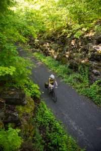
K&P Trail near Harrowsmith – Photo by Alija Bos
- K & P Trail – The K&P Trail is a 180-km multi-use recreational rail trail that connects downtown Kingston to the Town of Renfrew where it intersects with the Ottawa Valley Recreational Trail. Frontenac County owns and operates the 90 km stretch referred to as the “Frontenac K&P Trail” from KM 21 where the City of Kingston borders with the Township of South Frontenac, to KM 90 near Clarendon Station. In Frontenac County, the K&P Trail is a fully developed stone dust rail trail with stops in the communities of Sharbot Lake, Godfrey, Verona, and Harrowsmith along the way. The trail has numerous views of wild Canadian Shield landscapes and makes for the perfect weekend adventure by bike. An onward connection to Perth is mostly complete.
- The K&P Trail intersects with the Cataraqui Trail at Harrowsmith, 28km north of Kingston, where a connection east to Smiths Fall, Carleton Place and Ottawa is possible via Trans Canada Trail routing.
- See our blog Three K&P Trail Town Starts & Stellar Rides in Eastern Ontario for some trail itinerary ideas.
- Cataraqui Trail – 104 km four-season rail trail that traverses the region, from Strathcona to Smiths Falls, through Frontenac from just west of Harrosmith to just west of Chafey’s Lock. This trail is very scenic especially east of Sydenham, passing lakes, forests and rock cuts, through the Rideau Lakes and Frontenac Arch Biosphere. Note the trail is composed of various trail materials, crushed gravel to compacted earth and is suitable to hybrid, gravel and mountain bikes. Approximately 80 km of the trail is designated a part of the Trans Canada Trail system. For maps and trail information visit website.
- Kaladar Trail – Part of the Trans Canada Trail, this 17 km multi-use, unpaved trail links westerly Tweed (via Hastings County Trail) to Sharbot Lake in the east (via Central Frontenac Trailway). For more info, use the Trans Canada Trail website’s “Explore The Trail” feature to find access points.
- Shabomeka Lake Legpower Pathfinders Network (North Frontenac) – Located in North Frontenac, there are approximately 30 km of mountain bike trails between Little Shabomeka Lake and Missagagon Lake.
- K&P, Cataraqui, Ottawa Valley Recreational Trails – 380km Loop – This loop explores the best of rail trail riding in eastern Ontario, on what may become a signature route for Ontario’s eastern highlands. Starting in Sharbot Lake, the route follows the K&P Trail south to the Cataraquai Trail, following that trail all the way to Smiths Falls. Next, riders join the Ottawa Valley Recreational Trail (OVRT) from Smiths Falls to Renfrew and then head south on the K&P again to Calabogie, then following the K&P trail back to Sharbot Lake. Riders should be cautious as long sections of the route lack supportive infrastructure and towns and some sections of rail trails can be quite rough, though rewards are beautiful wild and rural scenery, unique small town eateries and coffee shops, and fascinating history and heritage.
- Trans Canada Trail – A portion of this cross-Canada trail runs through the region on the Central Frontenac Trailway, the K&P Trail, and the Cataraqui Trail from west of Harrowsmith to west of Chafey’s Lock. The route follows a highly scenic section of the Trans Canada Trail through the Rideau Lakes and Frontenac Arch Biosphere. Trail surfaces range from crushed gravel to compact earth with some rougher sections. Use the Trans Canada Trail website’s “Explore The Trail” feature to find access points. tctrail.ca/explore-the-trail
- Great Lakes Waterfront Trail – Following Lake Ontario’s shoreline from Niagara-on-the-Lake to Quebec, Lake Erie, and Lake Huron, this well-mapped and well-signed route offers a mixture of on- and off-road paved trails covering 3000km+. The trail through south eastern Ontario is an excellent touring option, taking cyclist across the region, with options to connect to the trail at many community start points or continue through as part of a longer itinerary. Through Frontenac the Trail travels through Kingston on a mix of roads and trails, with proposed optional routing on Wolfe Island. East of Kingston the Trail follows Highway 2 with an optional route onto Howe Island.
- Log Driver’s Waltz – The Log Driver’s Waltz is a gravel and off-road bike packing route developed by Jen Adams and Eric Betteridge with the southwestern tip of this route passed through the North Frontenac Highlands. With the original route stretching 600km and onto the Quebec side of the Ottawa River, a number of shorter, 3-4 day routes have been developed for cyclists looking for a more manageable exploration of this beautiful area in a shorter time frame.
- Great Lakes Seaway Trail – Leave from Wolfe Island, ON, for Cape Vincent, New York, to access this signed route that follows various roadways along Lake Ontario and the seaway on the US side.
- Eastern Ontario Trails – Multi-use trail network north from Bay of Quinte to Algonquin, linking outdoor recreation and adventure to the natural environment and communities along the way.
- Frontenac County Cycling Route Online and Interactive Map.
- Eastern Ontario Trails Association – Multi-use trail network north from Bay of Quinte to Algonquin, linking outdoor recreation and adventure to the natural environment and communities along the way. Also site to access Eastern Ontario Recreational Trails Map. Send an email request to receive print map to info@thetrail.ca
- RideGravel.ca – web resource for gravel and bikepacking routes in central and eastern, including a number in Frontenac County.
- Getaway Country Recreational Trails Map. Map. Advermap. 6th edition, 2010/2011.Available at various retailers and on-line: www.ontariotrailmap.ca & www.advermap.com
- Ontario Bike Trails – Find a useful map for rail trails across Ontario, including recent reviews, trail descriptions and photos.
*Please note there are many additional trails and information resources for the region that may be of interest and useful to cyclists. Changes to the above listings may occur. Contact us to share information and/or updates on area trails and routes
Frontenac County – Related Blogs:

Three K&P Trail Town Starts & Stellar Rides in Eastern Ontario
Get to know the K&P Trail and immerse yourself deep into the heart of Frontenac County, eastern Ontario, riding through pristine wilderness, farmlands and Canadian Shield. From three well situated trailside village start spots enjoy a cruisy day ride out and back from Sharbot Lake to Clarendon Station (north) or Verona and Harrowsmith (south). Or cut deeper into the treed forests and lake lands on extended gravel adventures and multi-day bikepacking adventures – the choices are boundless.

Easy Rider – Relaxed Cycling in Ontario’s Highlands
Not every bike ride needs to involve grueling hours spent on the road or trail. Sometimes the best rides are the ones where you take it easy, slow it down and see new communities, and maybe even stop for a bite to eat. If you’re not into wearing padded bike shorts and setting a challenging pace, plan your next ride in Ontario’s Highlands where your cycling adventure can match your mood, abilities, and bike.

Bikepacking in Ontario? Get Started Here
Bikepacking is a natural next step for those who love both cycling and camping, it truly is human power for the win. Over the past few years, Ontario’s Highlands has emerged as a bikepacker’s paradise. Before you head out, here are some tips for planning your first trip.

The Great Lakes Waterfront Trail, Two Days at a Time
Planning a cycling adventure in Ontario is challenging in the best possible way. There are so many options to choose from – touring routes, bike packing adventures, mountain bike trails, gravel loops – so much to explore, so little time. The impressive Great Lakes Waterfront Trail is one route worthy of any cyclist’s bucket list.
Destination Renewal Partner:

The post Frontenac County appeared first on Ontario By Bike.